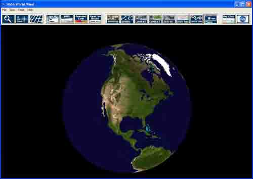
NASA has released a program that has absolutely blown me away. Worldwind allows you to view the entire planet in ways never before conceived, using satellite imagery and topographical data, right on your own PC. It's absolutely free, but you'll need a recent PC and a broadband connection to the Internet in order to use it.
The first step is to download the program. Version 1.2d is the latest as of this writing, and it can be downloaded here. But you may want to check out the official Worldwind download page just in case a new version has been released since.
Next install the program. Remember, you're going to need a decently fast PC (1 Ghz minimum), a video card that can handle 3D (like the ATI Radeon or the nVidia GeForce), and a good connection to the Internet (DSL or cable). You will also need to have Microsoft's .NET runtime and Microsoft DirectX 9b installed. The Worldwind installer comes with both of these programs, so you won't have to worry about it, but you can optionally install these from within Windows Update.
Now the fun part! When you run the program, you'll see the Earth. Hold down the left mouse button and move your mouse -- this is how you can move around to different parts of the globe. Now try holding down the right mouse button and moving your mouse -- this is how you rotate your viewpoint (we'll get back to that later). Next, try using the mouse wheel to zoom in and out. Clicking on any spot on the globe will center your viewpoint on that spot.
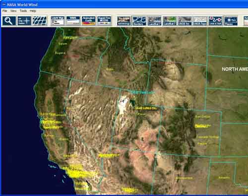
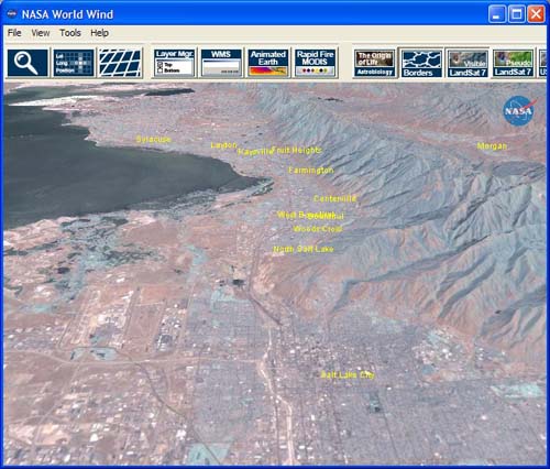
Hold down the left mouse button and move the globe around until you see North America. Now, click on the Borders button  in the toolbar -- this will highlight the state and country lines. To turn the lines off, just click the Borders button again. Now, let's find Salt Lake City, Utah. The Olympics were there a few years ago, and the mountains nearby make it a perfect city to illustrate what Worldwind can do, and the Great Salt Lake is easy to see from space. Click on Utah to center your view, then slowly zoom in until you see Salt Lake City. Center your view on the city and keep zooming in.
Once you zoom in closer, you'll begin to see grayish boxes with a red border overlay the map. The grayish boxes are satellite images. If it has a red border around it, it means that that part of the map is currently being downloaded from NASA. You'll also see an icon in the upper right hand corner of the screen whenever data is being downloaded.
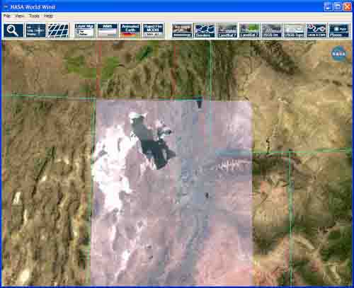
Once it has finished downloading, you should see something like this.
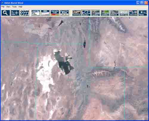
Zoom in further, and Worldwind will download higher resolution images, giving you greater and greater detail. Now, hold down the right-mouse button and move your mouse down a bit -- your view will rotate a bit, so rather than looking head-on at the city from above, you'll be looking at it from an angle. Notice how the mountains actually pop out of the terrain! Worldwind takes the satellite imagery and maps it ON TOP OF a topographical view of the world, so you can actually see the lay of the land!
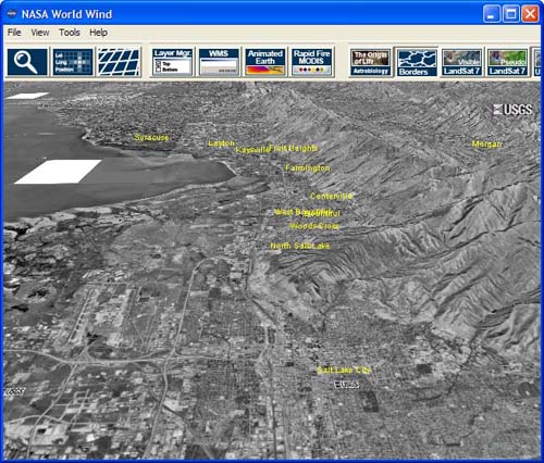
Now, what we've been looking at is images from the LandSat 7 satellite, which has images of the entire earth. But Worldwind gives you access to more! The entire US has been imaged by the USGS satellite, with a resolution of 1 meter. To see those images, which offer MUCH greater detail than the LandSat 7 satellite, click on USGS 1m button.  Here's the same shot, but with the USGS satellite:
Now, certain US cities have been imaged by a USGS satellite with a resoluteion of .25 meters, offering simply incredible views of these cities. To access the .25 meter satellite, click on the Layer Manager button.  The Layer Manager window will open. From here, click on the plus sign next to Images to expand those options. Next, expand the High Resolution Terrain Mapped Imagery section. Uncheck the box next to USGS Digital Ortho-Quandrangles and instead click the checkbox next to USGS Urban Area Ortho-Imagery -- this is the set of super high-resolution images we're looking for. You should immediately notice the difference -- color images instead of black and white, and HIGHLY detailed! Note that very few cities in the US are available via this satellite. If a particular part of the country is not available, all you will see is a blank white box where the city should be. Here's a comparison between the USGS 1m satellite and the USGS .25 meter satellite:
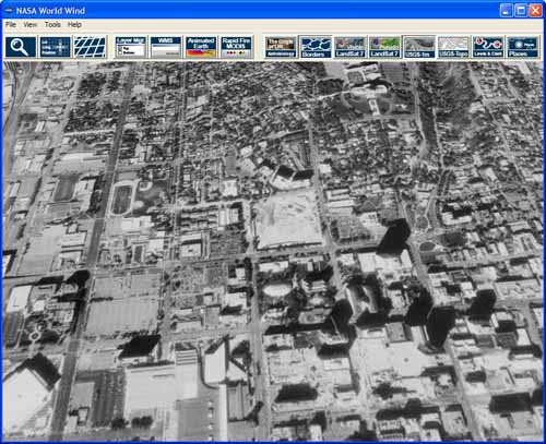
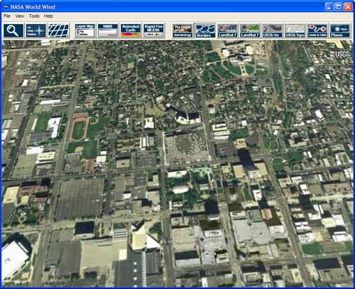
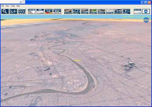
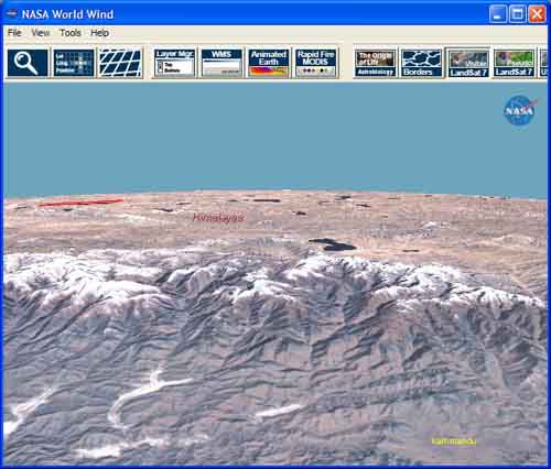
The photos don't do it justice -- you have to see the detail to believe it. Unfortunately, only the US has such detail available publicly, the rest of the world is only covered by the LandSat 7 satellite. But you can still visit cities and landscapes you never before have seen, like Baghdad to Kathmandu:
The NASA Worldwind forums are a great place to learn more or get help, or even talk to the developers of the software! Enjoy!